The Nakasendo Trail in Japan
An ancient route through Japan’s central mountains
The Nakasendo Trail, meaning “road through the central mountains”, was one of the five major highways of the Edo period. Stretching approximately 530 km between Edo, now Tokyo, and Kyoto, it crossed the mountains of central Japan and passed through 69 post towns.
Origins of the Nakasendo
The Nakasendo developed along travel corridors that had been used for centuries. In the early eighth century, Japan’s imperial government established a network of regional roads, including the Tōsandō, to support administration, troop movements and the collection of taxes.
The Tokugawa shogunate later reorganised parts of this earlier network into the centrally administered highway system of the Edo period.
The five highways of Edo-period Japan
After the Tokugawa shogunate was established in 1603, five major highways, known collectively as the Gokaidō, radiated from Nihonbashi in Edo. The shogunate administered these roads for political, military and economic purposes, maintaining post stations, checkpoints and transport services for official travellers.
Two of the highways connected Edo with Kyoto. The coastal Tōkaidō was flatter and carried more traffic, while the inland Nakasendo crossed the mountain ranges of central Japan. Its varied terrain made it a more demanding journey, but it remained an important route for officials, merchants, pilgrims and other travellers.
Sankin-kōtai and the daimyo processions
Under sankin-kōtai, or alternate attendance, daimyo were required to maintain residences in Edo and divide their time between the capital and their home domains. Their wives and heirs generally remained in Edo, while the expense of maintaining two households and travelling with large entourages helped reinforce the shogunate’s control.
Each procession reflected the wealth and status of the daimyo’s domain and could include large numbers of samurai, attendants, porters and horses. These frequent journeys placed considerable demands on the highway system and encouraged the development of roads, post towns and transport services.
Post towns, inns and barrier stations
The Nakasendo’s 69 post towns, known as shukuba, provided accommodation, food, horses and porters for people travelling along the highway. They also supported the movement of official correspondence, government supplies and goods between regions.
Each post town generally had a primary inn, or honjin, reserved for daimyo, court nobles and shogunate officials. A secondary inn, known as a waki-honjin, accommodated other high-ranking travellers and members of their entourages. Merchants, pilgrims, craftsmen and ordinary travellers stayed in the town’s other inns and lodgings.
Because a post town usually had only one honjin and one waki-honjin, the schedules of important travellers had to be carefully coordinated. Large processions also required considerable planning to secure sufficient accommodation, horses and porters.
Checkpoints, or seki, were established at strategic locations to control the movement of people, weapons and goods. Officials were particularly alert to weapons being carried towards Edo and to members of daimyo families attempting to leave the capital without permission. Kiso-Fukushima, one of the Nakasendo post towns, was also the site of one of the route’s most important checkpoints.
Control within the Kiso region extended to its highly valued forests. After extensive logging depleted local timber resources, the Owari domain introduced strict protections for five varieties known as the Five Trees of Kiso. Cutting one of these trees without permission could result in death, a warning remembered in the expression “one tree, one head”. The protected timber was reserved for important construction projects, including castles and shrines.
The Nakasendo between Edo and Kyoto
The Nakasendo extended for approximately 530 km between Edo and Kyoto. It ran inland through the varied terrain of central Japan, crossing plains, valleys and numerous mountain passes.
The route was not permanently fixed. Floods, landslides and damaged bridges sometimes required sections to be moved, while local communities were responsible for much of its ongoing maintenance.
The Kisoji and its 69 post towns
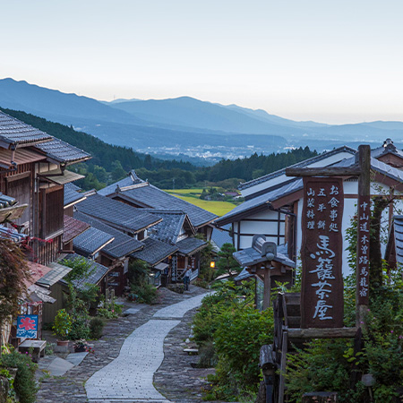
The central section through the Kiso Valley was known as the Kisoji, or Kiso Road. Eleven post towns stood along this mountain section of the Nakasendo, including Magome, Tsumago, Kiso-Fukushima and Narai.
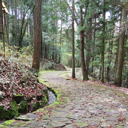
Much of the Nakasendo consisted of compacted earth and gravel, with stone paving added in some areas. It was travelled on foot, on horseback or in palanquins rather than by wheeled vehicles. Sections of the original route remain preserved between the historic post towns, allowing today’s walkers to experience the landscape at a similar pace to earlier travellers.
The highway of princesses
Although the Nakasendo crossed a number of difficult mountain passes, it avoided the broad and sometimes dangerous river crossings found along the coastal Tōkaidō. It was therefore chosen for several important marriage processions travelling from Kyoto towards Edo.
During the Edo period, women from the imperial family and other court families travelled east to marry into the Tokugawa shogunate and leading samurai households. These were large ceremonial journeys involving samurai, court officials, attendants, porters and extensive preparations throughout the post towns.
Among the best known was the journey of Princess Kazunomiya, who travelled along the Nakasendo in 1861 to marry Tokugawa Iemochi, the fourteenth shogun. Processions such as hers led to the route becoming known as Hime no kaidō, or the Highway of Princesses.
Travel, trade and everyday life along the Nakasendo
Although the highway system was created primarily for official use, the Nakasendo was travelled by people from across Edo-period society. Merchants carried goods between regions, pilgrims journeyed to temples and shrines, and monks, craftsmen, messengers and ordinary travellers shared the road with samurai and government officials.
Official traffic retained priority, but the growing movement of people and goods transformed the highway into an important network of commercial and cultural exchange. Regional products, news and ideas travelled along the route, while the post towns became places where people from different parts of Japan regularly met.
Post towns prospered by providing food, accommodation, transport and supplies. Inns, teahouses, shops and local markets served travellers, while residents earned income as porters, guides, innkeepers and providers of horses.
Ordinary travellers could choose accommodation according to their needs and budget. A hatagoya, or hatago, provided lodging together with meals. The more basic kichin-yado did not provide meals, so guests carried their own food and paid a small charge for the firewood used to prepare it.
As private travel and commerce increased, the post towns developed into thriving communities rather than simply stopping places for official processions. Their prosperity reflected the wider economic and social changes that took place during the long period of relative peace under the Tokugawa shogunate.
Decline and preservation of the Nakasendo
The restoration of imperial rule in 1868 brought the Tokugawa shogunate to an end, and the Nakasendo gradually lost its central role within Japan’s official transport system. New national roads and railways offered faster alternatives and redirected travellers and goods away from the old highway.
The effect on the post towns varied. Those connected to the developing railway network adapted to new forms of transport and commerce, while towns that were bypassed experienced a long period of decline. Tsumago, for example, lost much of its post-town function after a new road opened in 1892 and a nearby railway began operating in 1909.
Paradoxically, decades of limited development helped protect traditional buildings and street layouts that might otherwise have been replaced. As Japan modernised rapidly after the Second World War, local residents began to recognise the historical and cultural value of what remained.
In 1968, residents of Tsumago began a coordinated effort to preserve the town. They later adopted three guiding principles: buildings and land within the historic district were not to be sold, rented out or demolished. In 1976, Tsumago became one of Japan’s first nationally designated preservation districts for groups of traditional buildings.
The movement pioneered in Tsumago became a model for townscape preservation across Japan. Today, surviving post towns such as Tsumago, Magome and Narai, together with preserved sections of the original trail, allow visitors to experience the Nakasendo as both a historic route and a living cultural landscape.
Art and the Nakasendo
The landscapes and communities of the Nakasendo have long inspired artists, poets and writers. The route’s best-known artistic interpretation is the ukiyo-e woodblock series The Sixty-nine Stations of the Kisokaidō, created during the late Edo period by Keisai Eisen and Utagawa Hiroshige.
Eisen began the series, which Hiroshige later continued and completed. The prints depict post towns, mountain passes, river crossings and travellers moving through changing seasons and weather. Although artistic interpretations rather than literal records, they offer a vivid impression of how the journey was imagined and experienced during the Edo period.
Walk the Nakasendo with Kumano Camino
Walking the Nakasendo brings this history to life through preserved post towns, mountain trails and the landscapes of the Kiso Valley. Join experienced Australian Japan specialists on our small-group guided Nakasendo walking tour.